CycleStreets, providing cycle routing for the UK, is now available on Android – thanks to our new app. Download it from the Android Market now – for free!
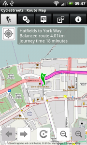
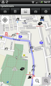
Our OpenStreetMap-based routing, for cyclists by cyclists, is now available on the move, complete with full placefinder, tap-to-set and with turn-by-turn directions.
Brought to you by CycleStreets, the UK-based cycle routing people, run on a not-for-profit basis.
Search for CycleStreets in the Android Market, use this link or use this QR code to download it directly:

Plan cycle-friendly routes from A to B anywhere in the UK!
- Plans routes through the full street and path network, including Sustrans routes and other networks
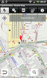
- Innovative & quick "three taps" system: Set current location, tap the map to set destination, and plan!
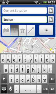
- Or search for any location in the UK, including full postcode support and local/national placefinder
- Choice of map styles (including OpenCycleMap showing contours, and Ordnance Survey Street View)
- Turn-by-turn itinerary view
- Choose from different types of routing – fastest/quietest/balanced/shortest
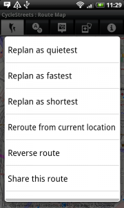
- Easily switch between route types (e.g. quietest to fastest) having planned a route
- Takes account of hills automatically
- Plan journeys up to 200 miles (320km) long
- Routes automatically saved for later viewing
- UK-wide (NB some areas of OpenStreetMap are better than others)
- Share your route to Twitter/Facebook easily
- Routing for cyclists, by cyclists: your input to OpenStreetMap very welcome
Cycle campaigners will love it too: Photomap photo facility
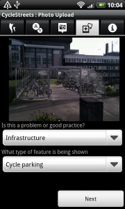
- Need some cycle parking in your area? Take a picture and add it to our Photomap
- Obstruction in the way? Report it! Or found an example of great infrastructure? Add it!
- Share your photo on Twitter/Facebook easily
- Browse the existing library of around 30,000 photos
- Full category and caption support
- Fully-integrated upload with automatic geolocation
- Locations used by campaigners around the UK
- Integrated signin facility
Part of the development of this App has been funded by Cycling Scotland.
We’d particularly like to thank our great volunteers who have put in an enormous amount of effort: Jez Higgins (our lead developer), Theodore Hong, Christopher Fraser, Jonathan Gray.
CycleStreets for Android is an open source project, and the code is available on GitHub. If you’d like to get involved with the coding to add new features, do get in touch.
24 thoughts to “CycleStreets for Android now available”
This comment form doesn't work on iOS – annoying!
The iPhone version seems to lack the 'replan' option – you have to recreate the route each time if you want to change the route type… Any chance of adding that?
Too bad it's only for UK. Are there any plans on expanding it? Maybe country per country to minimise the investments.
As a tip: Belgium is a small country :-)
I've just tried installing it on a 2 week old Samsung Galaxy S2 (Android 2.3.3) and it's telling me it's not compatible with this device. Any plans to expand the range of Android devices that this app will work on?
How do I plan a route from the current position (which it knows, since it has drawn a yellow figure on the map) to a location which I can select by tapping the map?
It appears I have to manually tap on the yellow man, which is error-prone and unnecessary., and then tap on the destination.
Alternatively, if I use Menu -> Plan a route, a dialog opens which by default sets the start point to my current location. However in that case I can't select the endpoint from the map: I am forced to enter an address or to choose a contact. (Pressing on the icon to the right of the destination field bring up a menu with one entry, "contacts").
HTC Desire, Android 2.2.
OK, so I've planned my first route and want to plan a new one. How do I reset the application to the state I was in when I first launched the application? (Where it asks "tap on map to define the start point").
If I use Menu -> "Plan a route", then it takes me into the dialog where I have to type in the start and end points. I notice that if I tap on the icons to the right of the start and end point fields I'm offered a menu which includes "Start point on map" and "Finish point on map". How do these work? Choosing one of these options simply offers me a rather arbitrary menu of recent postcodes: it doesn't allow me to tap on the map.
To plan another route tap the centre button at the bottom of the screen.
Can I download routes I have planned on line to my phone ? Or can I open them on my phone?
Many thanks
claudie
Jez – thanks for answering my second query. It was far from obvious what that button was for. Perhaps you should add this to the menu, or combine it with the "plan a route" menu option?
Is there an answer to my first question? I suspect what is needed is for the "plan a route" form to offer a way of selecting the end point from the map (rather than by typing it in or selecting from contacts).
Can I download routes I have mapped on cyclestreets.net to my app at all?
Can you please tell me if the app supports "App2SD"?
Nigel – the "Start point on map" and "Finish point on map" menu items refer to points on the map you have already set – the green start and red end markers – rather then points you will then set.
GrahamS – Yes, the app can be installed to SD card.
Great app, and great interface. A huge step forward from all the other mobile cycle route planning apps I have used.
But… Unless I am connected through WiFi then the route planning and place finding functions stop working. The map works OK and I can pin a start and end point, but beyong that nothing… In other words, I need to use WiFi to use this app.
Anyone else seeing this?
HTC Desire, Android 2.2
very slick for a first release guys !
A few minor niggles (in photoview, arrow head points east when pedalling west and south east when pedallign south west) , and some "curious" route choices , e.g. plotting a route from the Alway / Somerton / Ringland areas of Newport to John frost square in the city centre uses george street bridge rather than the millenium footbridge which is A) on a SUSTRANS route , B) quicker, C) way flatter! D) quicker .
so where do we provide feedback / bug reports please ?
Regards and well done again
BB
Map zooming is either impossibly slow or not working properly on motorola Defy and that is using my home wi-fi connection
@BigBloke – We're hoping to get feedback within the app itself soon.
However, for now if you get any dodgy routes, could you go to the route number via the website – see the journey number box in the top right at http://www.cyclestreets.net/journey/ – and on the page you get (which shows the route), submit feedback there?
I can reproduce that problem in Newport you mentioned, so have submitted a feedback report so it can be looked at as soon as we get a chance.
@Ruairidh – Can you try going to Settings and then changing to a different map background? It's possible that the tileserving on one of the map styles is being a bit slow today.
@Claudie Not yet, but calling up an existing route number is something we'd like to add.
@BigBoy – Actually you can already send feedback on a route from within the app. If you've planned a route and think it looks a bit wonky, just press and hold to bring up the context menu. At the top will be the various "Replan as …" options. If you scroll to the bottom of the menu, you'll find "Comment on this route". Hit that, fill in the comments box, hit Upload and you're done.
HTC Desire with Android 2.2.
When selecting start and end locations using postcodes or names a choose location window comes up that has nothing in it. It is also v small.
Hooray! Android app is great – just needs to be able to sync up with the journeys on the website, or include the ability to enter a journey number from the website and it'll be perfect – thanks for all your hard work :)
Pingback: Open Mobile Map » Weekly OSM Summary #22
Hi, what a fantastic app, great work!
one thing though – I'd like to use the app just to aid following (and finding) national cycle routes; on your web version they are clearly marked on the maps. However, on the android app version, they don't seem to be labelled. Am I missing something?
If the feature isn't there yet, I'd be happy to try and implement it myself – would it be fairly straightforwad?
Chris, Click on the last tab and then go into the settings. If you set the map style to 'OpenCycleMap' you'll see these.
This map style currently not set as the default, but may be in the future.
If you'd like to get involved with coding the app, do have a look here: http://www.cyclestreets.net/blog/2011/08/04/android-app-coders-wanted/
Pingback: CycleStreets » Blog