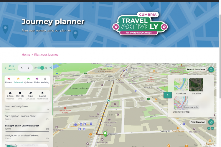
Journey planner for Ways around the Bay

Morecambe Bay Partnership has launched a brand-new, interactive route planning website called Ways Around The Bay designed to get locals and visitors exploring the beauty of Morecambe Bay in low-carbon ways. WaysAroundTheBay.org.uk is a resource for those who want to walk, cycle or head out on a wheelchair or all-terrain mobility scooter with a route […]

Read more
Batch (matrix) routing

Our routing has been used in a range of academic and transport planning projects. Because our routing aims to emulate as close as possible the route that a knowledgeable cyclist would take, creating a matrix of route results between sets of Origin<>Destination (OD) pairs facilitates various interesting statistical analyses of the quality of cycle infrastructure […]

Read more
Mapping modal filters and LTNs

Modal filters – measures such as bollards, gates, cycle contraflows, etc., are important ways to prevent motor traffic passing through residential areas. They have been much in the news recently, but are in fact very common, and have been in existence since at least the 1980s. However, there is no national mapping data on where […]

Read more
Dublin Region Active Travel Challenge

We’re proud to announce that, not one, but two of our new projects are finalists in the Active Travel Challenge being run by Smart Dublin. Smart Dublin brings together technology providers, academia and citizens to transform public services and enhance quality of life. The Challenge showcases how open data can be used to support and […]

Read more
R interface to CycleStreets routing

We’re pleased to announce the availability of a new CycleStreets R package that enables easy access to our routing API. It enables R programmers to calculates cyclable routes in a reproducible command line interface, and obtain detailed metadata, e.g. quietness, elevation change, etc. Quietness values within a route. See an interactive version of this map, […]

Read more
ActDev – Active travel in new developments

We’ve been working recently with Leeds University on a new project, ActDev – Active travel in new developments. The aim of the 4 month ActDev project, which was funded by UKRI, was to demonstrate what is possible with new datasets and methods to help people working in the planning system to support walking and cycling […]

Read more
Streetvisions – Widen My Path phase 2

Last year we created Widen My Path, enabling members of the public to say where improvements to streets are needed in order to facilitate physical distancing and increasing levels of walking & cycling. As we reported, it has seen over 238,000 user submissions (combined new points and likes), over 400 spreadsheet data downloads (plus more […]

Read more
2020 – a year in review

2020 has forced us to divert, dismount and widen our path! More and more people have discovered the joy of cycling this year because of the quieter streets resulting from the coronavirus pandemic. Our data interface has seen over 5 million itineraries planned. This drives our website, apps, and some third party apps and websites, […]

Read more
StreetFocus: Moving from beta to live

Following the launch of our beta site in March, just before lockdown hit us and disrupted many of our plans, we’re now busily working much more actively on StreetFocus again! We’re working towards a launch in April, with some tidying-up likely in May/June in response to user feedback. The key areas of work remaining are: […]

Read more
Privacy policy update

We’ve updated the privacy policy on our main site. This replaces our previous policy that had become rather old, and provides more detail. We aim at all times to operate a privacy-aware site that protects your rights.

Read more