Cycle routes very often use un-named paths. These create a headache for anyone who tries to give directions to a cyclist:
“take the cycleway alonsidge this road, at a junction with two other paths turn right under the bridge, then go down a snicket on the left …”
It’s a key issue for us trying to produce intelligible itinerary listings — and even more important for our sat nav users where the names are called out!
Some examples include:
- short links from a cul-de-sac onto one of a town’s radial routes
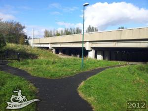
- useful permeability links or short-cuts often known by colloquial phrases such as jitties or snickets
- paths across open spaces
- roads that begin paved but farther down revert to a track
- bridleways
- redways in Milton Keynes, cycleways in Stevenage
- old railway lines that have become cycle routes (though these usually get a name)
- short links addded to join cycle routes – often forming the hypotenuse of a triangle
Direct tagging
CycleStreets uses the street name if directly tagged in OpenStreetMap. If the name is not available any cycle route tagging from the way or any of it’s relations is checked. This results in names such as NCN51 or CS3.
Using only direct tagging still leaves an awful lot of un-named ways. As a fallback they can inherit names from the ways they join. Depending on how many joins there are we’ve used names following these patterns:
- Link with …
- Link between … and …
- Link joining …, …, …
This has always been rather awkward and only slightly better than leaving them un-named. But when our sat nav apps call out such long conglomerations it sounds really painful — and something we just had to sort out!
Inferring better names
We’ve tackled this problem by using indirect data to invent more useful names. The result is that you’ll see the following phrases appearing in the street names of our itinerary listings:
‘Alley off …’
Where there’s a short un-named spur off a named way, for instance: Alley off Braithwaite Cresecent
‘… continuation’
An example is Gairbraid Avenue in Glasgow, the criteria used to identify these cases include:
- Short: up to about 100 metres – renaming very long ways that match stretches the credibility of the idea
- Only has two joints
- Continuations of ways join to only one other way at one end
- Cases where the joins at both ends are more complex are ignored.
‘… Blind Alley’
Like continuations but have connections only at one end, Canberra Close for example
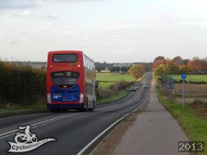
‘Alongside …’
Some very useful cycle routes often run alongside roads, and are also often un-named in OpenStreetMap. We detect these cases by checking that the name of the nearest road at several points along the length of the cycleway. If the same name matches at least 70% of the length then the cycleway inherits the name of the road by being prefixed with ‘Alongside’. As an added bonus, we added a little easter egg relating to road names with ‘Drive’ in them.
A good example of the alongside names are shown in this route and this one.
Other names
The techniques above result in more sensible names for many tens of thousands of ways in the British Isles. We use some more techniques for fixing names across open spaces and inferring names of very short links between named ways.
As a general principle we try to make best use of what data there already is in OSM rather than suggest new rules about how it should be used. But in doing this work we’ve noticed that some ways drawn in OSM carry on round the corner to run alongside differently named roads. Such cases won’t inherit the ‘Alongside …’ name because of the 70% quality threshold. To fix that those ways should be split at the corner. We did split the long cycleway between Cherry Hinton and Fulbourn at the point where the adjacent road changed its name.
The second street named in this route shows that we’ve still got a way to go to cover more cases for choosing better names, but as ever this work is ongoing.
5 thoughts to “What do you call a path alongside a road?”
Hi, names for cycle paths is a great idea but on which database are the names stored please? I’ve checked a couple of the examples given (Alley off Branthwaite Cresecent and Gairbraid Avenue continuation) on OSM and neither of them have any name tag info loaded.
There are many cycle paths here in Hamilton (New Zealand) which would be ideal for naming with tags as simple as “Street A – Street B link” but I wonder about the legitimacy of loading such unofficial / informal names to the OSM database.
Good question, and it seems I did not make this clear in the article. The names we invent are stored only in a CycleStreets’ database we do not feed these invented names into OSM – that would not be appropriate.
Clarity is the main requirement, on routes unknown to me these can be difficult to identify or even find.
Is there going to be any export to gpx, for those with GPS units that can’t plot their own routes?
All route listings have a .gpx download option. Just look for the phrase ‘GPS device export (GPX)’ on any listings page, such as: http://www.cyclestreets.net/journey/38569449/ (which was my little excursion this morning).
The grammar is rather odd though, “Bear right at Alongside …”
Surely something like “Bear right onto the path alongside the road” (that the user is already on) would be much better. Obviously that’s more complex, but I’d say it’s much more understandable.